


Spain Topo Maps

Opis Spain Topo Maps
+++ Nowa aplikacja do mapowania GPS +++
Łatwa w użyciu aplikacja GPS do nawigacji zewnętrznej / offline z dostępem do najlepszych map topograficznych i zdjęć lotniczych w Hiszpanii.
W tym Baleary i Wyspy Kanaryjskie
++ Do użycia w trybie offline potrzebne są funkcje PRO! ++
Zmień swój telefon / tablet Andoid w zewnętrzny GPS na wycieczki w backcountry BEZ POKRYWY KOMÓRKI. Ta aplikacja daje podobne opcje mapowania, jakie możesz wiedzieć z podręcznych urządzeń GPS.
Zawiera DARMOWE warstwy mapy:
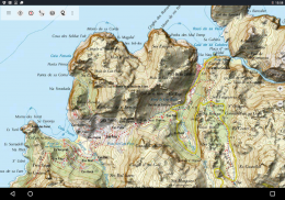
• Hiszpania Mapa topo: Mapa Topográfico Nacional 1: 50.000 i 1: 25.000 (IGN MTN25 i MTN50)
• Mapa bazowa IGN: Baza Topográfica Nacional 1: 25.000 (BTN25 i BCN25)
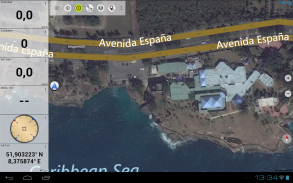
• Obrazy Hiszpanii: zdjęcia lotnicze o wysokiej rozdzielczości. Plan Nacional de Ortofotografía Aérea (PNOA)
• Catalonia Topo Maps: Mapy topograficzne o wysokiej rozdzielczości dla Katalonii
• Rejestr gruntów Mapa: Cartografía Catastral
• OpenStreetMaps: te mapy crowdsourcingu są bardzo przydatnym dodatkiem do innych warstw mapy. Zawiera wiele unikalnych funkcji.
• OpenCycleMaps: te mapy są idealne do planowania wycieczek rowerowych
• Topograficzny ESRI
• Obrazy lotnicze ESRI
• Mapa uliczna ESRI
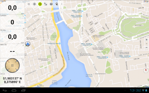
• Google Road Map (tylko dostęp online)
• Obrazy satelitarne Google (tylko dostęp online)
• Google Terrain Map (tylko dostęp online)
• Mapa drogowa Bing (tylko dostęp online)
• Obrazy satelitarne Bing (tylko dostęp online)
• Ziemia w nocy
• Nakładka Hillshading
Główne funkcje nawigacji zewnętrznej:
• Twórz i edytuj punkty trasy
• Nawigacja do punktu nawigacyjnego
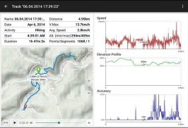
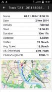
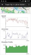
• Nagrywanie ścieżki (z profilem prędkości, wysokości i dokładności)
• Tripmaster z polami do licznika kilometrów, średniej prędkości, namiaru, wysokości itp.
• Eksport GPX / KML / KMZ
• Szukaj (nazwy miejsc, POI, ulice)
• Konfigurowalne pola danych w widoku mapy i Tripmaster (np. Prędkość, odległość, kompas, ...)
• Udostępnianie punktów trasy, utworów lub tras (za pośrednictwem poczty e-mail, Whatsapp, Dropbox, Facebook, ..)
• Wyświetl współrzędne w Lat / Lon, UTM lub MGRS / USNG (Military Grid / US National Grid)
• Nagrywaj i udostępniaj ścieżki ze statystykami i profilem wysokości
• Obróć mapę (Track Up i North Up)
• Uzyskaj wysokość przez długie kliknięcie mapy
• Odtwórz powtórkę
• i wiele więcej ...
Dostępne funkcje Pro: (funkcje Pro dostępne za pośrednictwem zakupu w aplikacji)
• Tryb offline - nie wymaga zasięgu komórki
• Łatwe i szybkie pobieranie zbiorcze kafelków map do wykorzystania w trybie offline (nie dotyczy map Google i Bing)
• Twórz i edytuj trasy
• Nawigacja po trasie (nawigacja punkt-punkt)
• Import GPX / KML / KMZ
• nieograniczone punkty i ślady
• Dodaj inny serwer kafelków mapy
• Bez reklam
Tryb offline:
Wszystkie oglądane kafelki mapy są przechowywane w pamięci podręcznej. Aby buforować duże obszary, musisz kupić funkcje Pro.
Korzystaj z tej aplikacji nawigacyjnej do zajęć na świeżym powietrzu, takich jak piesze wycieczki, jazda na rowerze, camping, wspinaczka, jazda konna, jazda na nartach, kajakarstwo, polowanie, offroad 4WD wycieczki lub search & rescue (SAR).
Dodaj niestandardowe punkty drogi w formacie długości / szerokości geograficznej, UTM lub MGRS / USNG z układem odniesienia WGS84.
Import / Eksport / Udostępnianie GPS-Waypoints / Tracks / Trasy w formacie GPX lub Google Earth KML / KMZ.
Wczytaj BEZPŁATNIE dane mapy dla obszarów bez usługi komórkowej (funkcja Pro!).
Komentarze i prośby o funkcje do spainmaps@atlogis.com
Sprawdź inne nasze aplikacje do nawigacji zewnętrznej: https://play.google.com/store/search?q=atlogis
+++ NIE śledzimy żadnych działań użytkownika ani nie gromadzimy żadnych danych użytkownika! +++
Spain Topo Maps - Wersja 7.7.0
(20-02-2025)
Spain Topo Maps - Informacje APK
Wersja APK: 7.7.0Pakiet: com.atlogis.spainNajnowsza wersja Spain Topo Maps
Inne wersje


Apki w tej samej kategorii


